Jomolhari Laya Gasa Trek ( 12 Days)
|
|
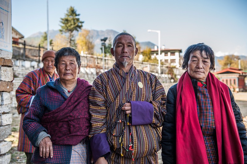
The Laya-Gasa Trek is considered one of the most scenic treks in Bhutan, offering amazing views of some of the most pristine and unspoiled landscapes in Bhutan. This fourteen day, 217 km journey begins at Drukgyel in Paro and takes you through gorgeous alpine meadows, high mountain passes and dense sub-tropical jungles before terminating in Damji in Tashithang. The first five days of this trek follow the same route as the Jomolhari Trek I through Jigme Singye National Park and offer awe-inspiring views of Mt. Jomolhari, Jichu Drake and Tsherimgang. On the sixth day the path diverges and you will depart Lingshi for the camp site at Chebisa, a charming little village adorned with a beautiful waterfall of crystal clear water. Along the trail you’ll be able to spot indigenous animals such as blue sheep and Takins, the national animal of Bhutan. You’ll travel through remote mountain villages inhabited by Layaps (people of Laya), a distinct segment of the Bhutanese society.
Day 1 Gunitsawa Village to Sharna Zampa
40mins, 80 m descent, camp altitude 2,850 m. This trek begins at Gunitsawa Village were you pass the army post. At the army checkpost your trek permit (provided by your tour operator) will be checked and endorsed. The campsite is on the opposite side of the river, not far from Gunitsawa.
Day 2 Sharna Zampa to Thangthangkha
Distance 22 km, 7-8 hours, 770 m ascent, 10 m descent, camp altitude 3,610 m. On this long day, the trail continues with lots of small ups and downs. After going uphill through the river valley the valley finally narrows gradually to a mere path which descends to a meadow.
Day 3 Thangthangkha to Jangothang
Distance 19 km, 5-6 hours, 480 m ascent, camp altitude 4,080 m. If you did not see Mt. Jomolhari the previous evening, you will still have a chance to get a great view early this morning. This morning the trek continues up the Paro Chhu valley which widens into patches of alpine meadow.
Day 4 Jangothang Halt
The rest day in Jangothang provides plenty of possibilities for day hikes with great views of lakes and snow capped mountains such as Jomolhari and Jichu Drake. There are good chances to spot some blue sheep on the upper slopes of the valley. Jangothang is a perfect environment.
Day 5 Jangothang to Lingshi
Distance 18 km, 6-7 hours, 840 m ascent, 870 m descent, camp altitude 4,010 m. This is one of the longest days of the trek. A short distance from the camp the trail begins climbing rapidly for about half an hour and then becomes a gradual ascent to the Nyilila pass at 4,870m.
Day 6 Lingshi to Chebisa
Distance 10 km, 5-6 hours, 280 m ascent, 410 m descent, camp altitude 3,880 m. Today is the shortest walking day, and you can really take it easy. Shortly after starting you will reach a chorten below Lingshi Dzong.
Day 7 Chebisa to Shomuthang
Distance 17 km, 6-7 hours, 890 m ascent, 540 m descent, camp altitude 4,220 m. The morning starts with a long ascent behind Chebisa Village (2-3 hours) through a wide pastureland towards Gobu La (pass). On the way, you will see a few people herding yaks.
Day 8 Shomuthang to Robluthang
Distance 18 km, 6-7 hours, 700 m ascent, 760 m descent, camp altitude 4,160 m. You begin by climbing up the valley to view Kang Bum (6,526 m) and some edelweiss. After two hours of climbing you will reach Jhari La (4,750m), from where you catch the first glimpse of Sinche La.
Day 9 Robluthang to Limithang
Distance 19 km, 6-7 hours, 850 m ascent, 870 m descent, camp altitude 4,140 m. The trek starts out with an initial 40-60mins ascent before gradually raising for another 1.5 hours through a boulder field. It is then a 1 hour steep ascent before reaching Sinche La (5,005m).
Day 10 Limithang to Laya
Distance 10 km, 4-5 hours, 60 m ascent, 340 m descent, camp altitude 3,840 m. Today, you walk downhill all the way along a narrow, winding river valley. After a long time, the trail takes you through densely forested region. The trail leads you to the west side of Laya village.
Day 11 Laya to Koina
Distance 19 km, 6-7 hours, 260 m ascent, 1,070 m descent, camp altitude 3,050 m. The trail winds up and down along the river valley of Mo Chhu avoiding natural obstacles and affording breath-taking views of the raging river, feeder streams and waterfalls.
Day 12 Koina to Gasa
Distance 14 km, 6-7 hours, 740 m ascent, 1,500 m descent, camp altitude 2,240 m. Today you will have the last major climb of the Laya Gasa Trek. You will cross Bari La (3,740m), after which the trail descends all the way until you reach Gasa village (2,770m).